Some of you may know that I have been conducting research into the “Lost Village of Silverley” and although my findings are limited, I would like to share them with you. Just maybe some more information might be forthcoming and we can fill in a few more gaps.
Before I start, I would like to acknowledge the work of Robert Halliwell. His article, “The Churches of Ashley and Silverley”, published in the Proceedings of the Cambridge Antiquarian Society, Vol LXXIII in 1984, is an extensive treatise on the subject covering the ecclesiastical history of the villages, but with no information regarding the location of the village of Silverley. I am indebted to him for the useful information contained therein and urge anyone who wishes a much greater understanding of local church history to consult his article.
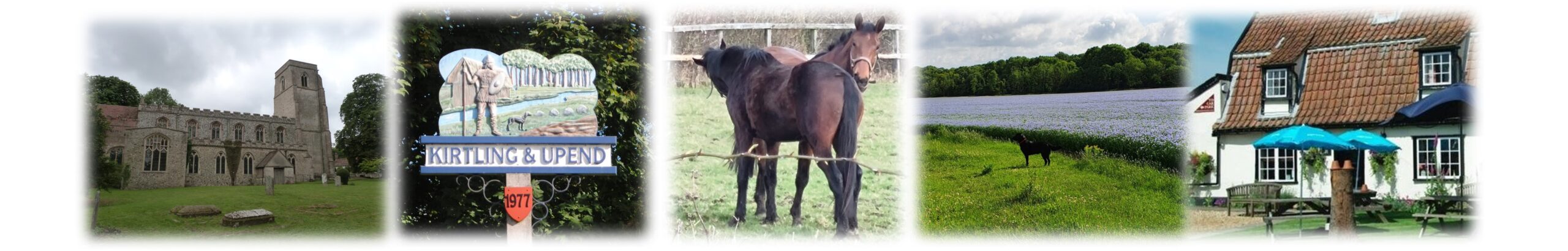
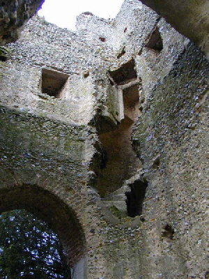
Silverly Tower West Face
Silverley
Just barely big enough to be mentioned in the Domesday Book, Silverley was larger than its neighbour, Ashley. Popularly thought to have died out in the plague, Silverley was still there and active after the plague of 1340. At the time of the 1660 plague the villages had combined to be “Ashley-cum-Silverley” and by 1674 there were 41 householders for the purpose of the Hearth Tax. In 1705 Thomas Serancke, rector of Ashley from 1682 to 1730, observed in a reply to a questionnaire circulated to the clergy, “ …………. We have the ruins of both Churches (St Mary’s, Ashley and All Saints, Silverley), but both so dilapidated that they are wholly out of use…………..”
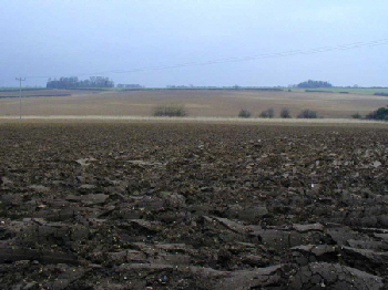
In 1752, William Cole during a tour of the Chiltern Hundreds observed, “There is but one church remaining in this depopulated parish, and nothing of the church but the tower………….” This refers to All Saint’s, Silverley. While I have no direct evidence of the demise of Silverley as a population centre, the above suggests it was virtually gone by 1705. Now, there is no sign of the village and no records of where the buildings stood. Maps from 1830 show no real signs of habitation and while Silverley was big enough to leave substantial archaeology, there seems to be none. Where was the village? What happened to it? At present, there are no more than 7 dwellings in the village and the oldest house is thought to be no earlier than 1740, so a substantial village vanished; and no-one seems to know why.
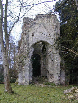
Chapel Row. Ashley from St John’s Chapel Site
Let’s look at it in more detail. Silverley stands at the junction of the boulder clay and chalk soils, not far from the River Kennett valley, which would have made it ideal for one of the many Anglo Saxon bases for forest clearance. There were 3 places of worship in the immediate area, being All Saint’s Church, Silverley; St Mary’s Church, Ashley and Ashley chapel.
This gives rise to an interesting theory. We all assume Ashley has been in its current location for ever and so has Silverley, but St Mary’s Church, Ashley is at least a mile from the present village. Either Ashley was in a different location, or there was a third settlement in the area.
There is an indirect record in the institution registers of the Diocese of Norwich of the advowson being presented to the priory of Silverley in 1177, which could be the earliest evidence of a church in the village but the first specific reference to churches in both villages is contained in the Norwich Valuation of 1254, which recorded both villages as separate parishes.
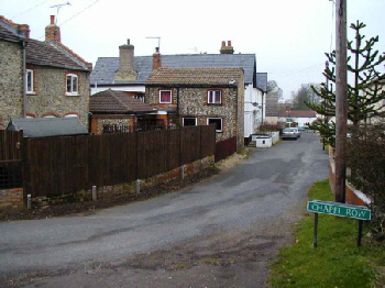
The chapel, according to the plaque embedded in the wall which now marks the site, was founded on October 25th 1277. This date could be taken as marking the start of the migration from the St. Mary’s and All Saints areas to the present Ashley site, because in 1300 at a Quo Warranto enquiry, the jurors of Chiltern Hundred declared Silverley to be a hamlet.
Just to put things into proportion, here are 2 valuations for the villages. In 1254, Silverley was worth £10 6s 8d (£10.33p), Ashley 20s. (£1.00p) In 1291, Silverley was valued at £17 6s 8d (£17.33p), Ashley, £6 13s 4d (£6.67p). It’s easy to see Silverley was the largest settlement by a good margin. So did 1277, when the need for a place of worship in Ashley was identified, see the start of the decline of Silverley? This is a good example of how confusing old records can be. In 1291 Silverley is 3 times the value of Ashley, but in 1300 is it declared a hamlet.
Ashley Plaque
Going back a little further, there is another consideration. At the time of the Norman Conquest it was considered very important for the invading French to establish their authority and to this end they built well defended manorial sites all over the place. If you go up the hill from Silverley towards Ashley, you will see 2 wooded areas to your right, one about 500m across the field and the other nearer 900m. The sites are called “Sylhall” and “Geysnes” respectively.
They are what are known as ‘Medieval Moated Sites’. Now then, don’t run away with the idea that the only things to have moats in Norman times were huge manor houses. Often, a moat was used as either a defensive mechanism or as a demonstration of authority and around such places as livestock yards or cultivated areas. Sylhall, closest to the road, is the largest and the name seems to be a corruption of Silverley Hall, suggesting this might indeed have been a Manor House. The moat is 11m wide by 3m deep.
There are 3 areas considered to be the sites of buildings and the site, although not accurately dated, would probably have been constructed around 1200. Geysnes, the smaller site, has an even bigger moat, some 16m wide by 3m deep. This site is laid out to strongly suggest a garden or herbary separated from buildings. Again, very likely to be a moated hall and probably dating from around 1200. The name comes from the De Guisnes family who held the manor of Ashley between 1166 and 1303 and this presents another anomaly. Firstly, it is generally accepted the 2 sites had no connection and stood in different parishes. Secondly, Norman families would often attempt to anglicise themselves by adopted a new name taken from the area in which they lived, so we have a family probably living in an area called Geysns.
I’ve never heard of it, but Geysns is the name of an old established farming manor in Wickhambrook. By the way, please excuse the various spellings of “Geysns”. It has changed over the years. So; what have we got? The small village of Silverley, overlooked by the imposing Silverley Hall, and Geysnes not 500m away, overlooking. . . . . what? Given it’s proximity to the old St Mary’s Church, I would suggest there was a substantial population centre there, otherwise why would the Normans want to make this statement of authority with the moated Geysnes site? The whole issue of these 2 sites casts a completely new light on the whole area.
Geysnes Sylhall from Church site
There is a popular supposition locally that Silverley was a plague village and rather than the population migrating to Ashley, they all died. In fact, both these theories can be disproved, although the records become confusing to say the least. We have already suggested that in 1291 Silverley was 3 times the size of Ashley, but to simply accept this on the face of the valuations would be wrong as I cannot state the criteria on which they are based. It is a guideline and in the absence of any other, it’s the best comparison we have. During the 13th Century the Knights Hospitallers of Chippenham accumulated property in Ashley and Silverley until nearly half their lands came to lie in these 2 villages and in 1338 these lands were considered to form a separate estate.
Given that Kirtling was a very important village at the time perhaps we can start to see why the Normans took such an interest in the area. 14th Century tax returns refer to “Ashley-cum-Silverley” and the Poll Tax of 1377 shows 116 taxpayers, evidence of growth within both communities.
Unfortunately, we now have to jump a hundred years or so because there is little material concerning the villages during the later Middle Ages, but the lay subsidy (1522-24) recorded 36 heads of households, the Bishop’s return (1603), 120 communicants and the Hearth Tax of 1666 and 1674 recording 43 householders and 41 householders respectively. All this translates to about 200 inhabitants, more evidence of growth.
So far we’ve said nothing about movement of population and the reason for this is simple. There are no records of migration between the 2 centres and the gradual decline of Silverley can only be guessed at from church records. There is definite evidence both St Mary’s and All Saints were both in use between 1516 and 1564 with 9 requests for burial at Ashley and 5 at Silverley. There is one very interesting burial request. In 1516 Thomas Lancaster asked to be buried within the church “In the aisle before the Trinity alter”. This implies the presence of more than 1 alter and perhaps side aisles to house them, suggesting All Saints was bigger and more important than it should have been for such a small village.
On the other hand, George Boissier, writing in 1827 before the area was planted, said the church had consisted of a nave, chancel and north and south porches. Perhaps the areas referred to as the north and south porches could have housed extra alters. A geophysical survey of the site might yield fascinating results. The last request for burial at Silverley seems to be that of John Colet in 1564.
Silverley Tower Interior
In 1540, when the preceptory of Chippenham was dissolved and its property granted to Sir Edward (later ‘Baron’) North of Kirtling, the rectory of Silverley also came into his possession and when in 1554 the living became vacant, he appointed Geoffrey Jones, Rector of Ashley, to this post effectively uniting the 2 parishes and in 1555 the Bishop of Norwich officially sanctioned this unification. All Saints Church was definitely in use in 1562 when Thomas Parker of Ashley left 3s 6d (17.5 pence!!) in his will for the upkeep of the building, but the 1564 burial request seems to have marked the end of its usage. In 1586, William Harrison produced the 2nd edition of his description of England for Raphael Holinshead’s ‘Chronicle of Great Britain’ and refers to the use of a chapel on Ashley Green with the clear implication All Saints Church was being used as a barn. There is also a very definite suggestion that the population was almost wholly in the present village of Ashley.
So, what have we got? Plenty of questions, really. A seemingly tiny population centre and an even smaller hamlet attract the attentions of the Knights Hospitallers, the powerful De Guisnes family who built a moated hall, another family who built another moated hall nearby, 2 churches, All Saints Silverley possibly multi-aisled with several alters and an area with apparently no archeological records of anything at all! Looking a little further back there are a few isolated archaeological finds. Between Geysnes and the old St Mary’s Church site some Roman tiles and pot scatter were found, a Bronze Age spearhead nearby, some ring ditches and some ridge and furrow. It’s an incredibly small amount for the area. I’d like to try a few theories of my own here. If you look from Ashley down to Silverley you will see All Saints Church stood on what was almost an island. The road falls away from it on all sides except to Upend, but the land along that road, together with the virtually total lack of finds in the area, suggest drastic re-profiling of the landscape. On the East side of the road the fields maintain a far more traditional layout and the raised church site might have been a very important religious area for many years. It could also be the area was not drained as it is today, and the site could really have been an island or at least have a substantial river close by. Just maybe All Saints Church stands on the site of a very much older building. The Roman tile and pot scatter near Geysnes could simply be some rubbish falling off a passing cart, but surely it’s possible there may have been a Roman settlement there.
Coming right up to date, Silverley church tower was quite well preserved until 1971 with 3 storeys discernible and 4 “Y” tracery windows about 2m tall. The trees, planted in 1851, had grown to the same height as the tower and in 1971 the misinterpretation of a report that these trees were unsafe led to the attempted demolition of the tower. A lot of damage was done and it was only the prompt action of the villagers which prevented the tower from disappearing altogether.
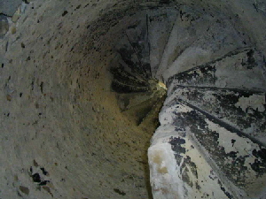
Silverley Tower Spiral Staircase
I hope this has explained a bit more about Silverley and its history and I hope you have enjoyed reading it. Yes, it’s confusing in places, but history’s like that.
You can consult records of different valuations and taxes but because the Hearth Tax was based on entirely different criteria than, for instance, the Poll Tax, conclusions are hard to draw and often misleading. If it’s encouraged you to think about the area in a new light, so much the better. Personally, I’m left with more questions than ever and I would dearly love to answer some of them.
I know most of the history here is based around the churches, but that’s often the way it is. The church was the most important point in the village and often the rector was the only person sufficiently educated to keep records, so inevitably the churches figure prominently. I would like to point out that the ecclesiastical history of the area does not concern me as it is so well documented. It’s the village that interests me. Where was it? Maybe it wasn’t near the church at all. If there was no population centre around St Mary’s, then maybe the same holds good for All Saints.
It could be that the old Silverley is the modern Cropley Grove. I don’t think it’s likely, but the supposition the village was around the church may not be correct. Anyone out there with any answers? It has been my intention, with the support of the local landowners and the villagers of Silverley, to carry out more physical research with a field walk and metal detector survey of the area. I’ll let you know when it happens and you will be welcome to come along and help.
Paul Saunders